Information on ORV Use in Michigan
Back
to Main Trail Info Page
  
There are over 3000 miles of designated ORV Trails in Michigan
– do you know where you can ride?
The use of Off Road Vehicles (ORV) is regulated in the State of Michigan.
Overview:
Must be 12 or older, wear a helmet and eye protection. Have an ORV sticker, spark arrestor, quiet.
Legal on open county roads and designated ORV Trails and ORV Routes.
When on county roads, speed is limited to 25MPH and must be on the far right side of the road surface.
There are lots of public roads on State Land that are NOT county roads and NOT open to ORVs.
Snowmobile Trails are not open to ORVs, though there are dual-use trails that are designated open to both ORVs and Snowmobiles.
State and Federal highways are not open to ORVs, nor are Expressways.
Details:
Off Road Vehicles describes many different vehicle types. Motorcycles, All Terrain Vehicles (ATV), Dune Buggies, Recreational Utility Vehicles (RUV) and 4x4 Pickups are all types of ORVs. Some of these vehicles can be licensed by the Secretary of State to enable their use on public roads and highways, as with the family passenger car.
License:
To use an ORV on Public land, it must be licensed by the Michigan Department of Natural Resources (DNR). This license is commonly referred to as an "ORV Sticker". ORV stickers can be obtained from most sporting goods stores as well as online from the DNR's website at michigan.gov/dnr. All ORVs operating off of private land require the "base" ORV Sticker which is $26.25. If they are also operating on MI's ORV Trails, thye also need the "Trail" ORV Sticker which is $10 ($36.25 total if riding trails).
Equipment:
ORVs must have an USFS approved spark arrestor and not exceed the 94db sound limit. Most competition motorcycles and ATVs do not meet these requirements, conversely most trail or utility oriented bikes and ATVs do.
Lights are required for operation after dark. Headlight and taillight are required at all times when operating on County Roads designated as open for ORV use.
Safety Gear:
ORV operators must wear a helmet and protective eye ware. It's highly recommended that you "dress for the crash, not for the ride" which basically means wear as much protective gear as is reasonable in addition to the minimum helmet & goggles.
Age Restrictions:
There are age restrictions for certain types of ORVs which mainly deal with ATVs (three and four wheelers). Basically, all riders under age 16 must take an ORV Safety Course before they may operate an ORV. No riders under age 12 on an ATV. No three wheelers unless they are over 16. Similar restrictions are not placed on motorcycles or large ORVs (dune buggies, etc.).
There are pending legislative changes that would prevent or restrict those without a valid drivers license from operating a full-size ORV (such as a dune buggy or pickup).
Where can you Ride:
Your own private property and the private property of others that you have written permission to use are allowed.
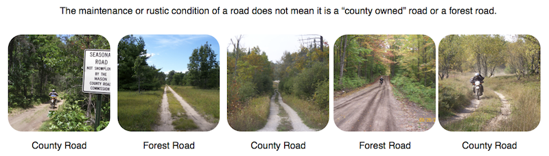
County Roads are allowed where the county or township has designated the road to be open through a local ordinance. County roads include those roads signed with "seasonal road" signs. County roads should have regular road signs such as street names and stop signs but many rural "seasonal" county roads do not have such signs. A map showing county roads is one of the best means to know which roads are under the county's jurisdiction. There are also speed, position, seasonal and time restrictions that vary by county. Generally 25MPH and far right of the maintained portion of the road. Our maps show which roads are county roads and open to ORVs.
Forest roads on State land in the upper peninsula are open, unless they are bermed, gated or otherwise posted as closed to ORVs.
Forest roads on State land in the lower peninsula are NOT open to ORVs unless they are designated and signed as ORV Routes.
Forest roads on National Forest land in the upper peninsula MAY be open to ORVs and will depend on the current Motor Vehicle Use Map published by each National Forest District. Their map is the authoritative source for which roads are open to ORVs as well as street licensed vehicles on National Forest land. National Forest roads generally have a carsonite marker with the assigned 4 digit road name, but neither the existence nor the placement of the marker defines what vehicle type is allowed on that road. Our maps include the current MVUM for each forest.
Forest roads on National Forest land in the lower peninsula follow the same rule as the upper peninsula with the main difference being no more than a handful of roads are open to ORVs.
Forest roads on private land in the upper peninsula that participate in the commercial forest act can allow ORVs for the purpose of hunting and fishing. They may allow, or tolerate, recreational use of ORVs. Vehicular access is not required for participation in the commercial forest act, it is up to the property owner.
Designated System:
The State has an extensive ORV Trail System that includes over 3000 miles of designated riding opportunities.
Designated refers to being posted open, signed with official markers. The ORV Trail System is managed by the Department of Natural Resources.
The current Trail System markers are orange triangles posted on trees, poles or carsonite markers. There are plans within the DNR to change to a newer yellow marker.
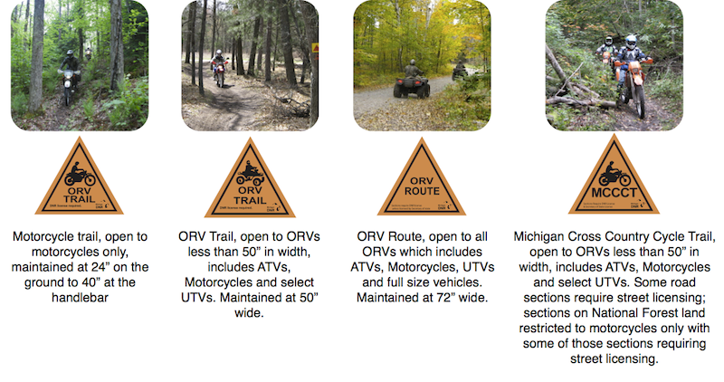
The ORV Trail System is comprised of four trail types:
ORV Route: These are 72 inches wide and open to all types of ORVs from motorcycles through full size vehicles. ORV Routes are generally forest roads, though they can include county roads. They frequently are also designated snowmobile trail BUT most snowmobile trails are NOT ORV Routes.
ORV Trail: These are narrow paths, open to ORVs less than 50 inches in width. This includes motorcycles, most ATVs and select UTVs. Full size vehicles are not allowed. Designated with an orange triangle with a picture of an ATV with the phrase "ORV Trail". Some ORV Trails on National forest land are only open to ATVs and Motorcycles, not UTVs regardless of width.
Motorcycle Trail: These are narrower paths open only to motorcycles. They are maintained at 24" at the ground up to 40" at handlebar height. Designated with an orange triangle with a picture of a motorcycle with the phrase "ORV Trail".
Michigan Cross Country Cycle Trail: These are connector trails and roads that link different trail systems together in the lower peninsula. They are designated with an orange triangle that has a motorcycle and the phrase "MCCCT". They are generally maintained as motorcycle trail though no sections on State land are designated as such currently. Sections on State land are open to ORVs including ATVs, sections on county roads may require street licensing unless the county has designated the road open, sections on National Forest are restricted to motorcycles and also require street licensing for some of those sections. The MCCCT does use some sections of State Highway that require street licensing.
ORV Use Areas: These are designated areas that allow cross-country travel, in that a designated Trail or Route is not required for travel. Also known as "scramble areas". These "Use Areas" are Silver Lake State Park, south of Ludington; The Mounds, north of Flint; Black Mountain, near Black Lake; St Helen Motorsports Area, east of St Helen, a small area near the southern Gladwin ORV Trail; a smaller area on the Evart Motorcycle trail; a small hill climb on the Bull Gap Trail; a small sand bowl known as the Thunder Bowl approximately halfway between Manistique and Marquette.
Legal/Info/Reference:
ORVs are governed by statute in Public Act 451 of 1994.
https://legislature.mi.gov/doc.aspx?mcl-451-1994-III-4-6-OFF-ROAD-RECREATION-VEHICLES-811
The law recognizes one type of Trail, which is open to any vehicle less than 50 inches in width.
https://legislature.mi.gov/doc.aspx?mcl-324-81101
The DNR has issued rules that restrict some Trails to even narrower widths and specific vehicle types, which is how we have motorcycle-only trails.
https://www.michigan.gov/documents/dnr/LUSE_ORD_176311_7.html
The DNR has issued additional rules that allow ORVs on select forest roads which is how we have ORV Routes.
https://www7.dleg.state.mi.us/orr/Files/AdminCode/949_2010-014NR_AdminCode.pdf
Counties and Townships can allow ORVs on their roads due to Public Act 240 of 2008. Counties that can, but not necessarily do, allow ORVs on their roads:
Oceana, Newaygo, Montcalm, Gratiot, Saginaw, Tuscola, or Sanilac county or a county lying north thereof, including all of the counties of the Upper Peninsula. Also St Clair County.
https://legislature.mi.gov/doc.aspx?mcl-324-81131
United States Department of Agriculture, Forest Service manages the National Forest lands in the State. Their Motor Vehicle Use Map is the authoritative source for which roads and trails are open to wheeled motorized vehicles.
https://www.fs.fed.us/recreation/programs/ohv/ohv_maps.shtml
Michigan DNR ORV Program:
https://www.michigan.gov/dnr/0,1607,7-153-10365_15070---,00.html
Michigan DNR sponsored ORV Handbook:
https://www.offroad-ed.com/mi/handbook/
Commercial Forest Act:
https://www.michigan.gov/dnr/0,4570,7-153-30301_30505_34240-34016--,00.html
https://legislature.mi.gov/doc.aspx?mcl-324-51113
VVMapping list of counties with copies of ordinances plus custom maps showing which roads are open:
https://www.vvmapping.com/micounty
VVMapping ORV Trail Guide including trail maps, descriptions, photos and videos of each trail:
https://www.vvmapping.com/miorv
|

