|
|
Maps for your GPS GPS compatible maps of Indiana's Snowmobile Trail System Version 3.0.0 (1/9/12) is available for FREE (download is free). Download it for free now: Mac or Windows Note: This GPS Map is included on our pre-loaded memory cards when purchasing the Great Lakes Snowmobile GPS Map.
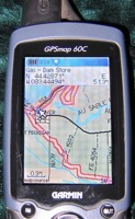
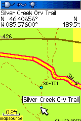
Overview of map features and as seen on the GPS Screen. Covers all of Indiana. The Snowmobile Trail
systems as well as the ORV Trail Areas are included as depicted by the IN DNR as well as updated data from local Clubs. No accuracy is claimed
on the trails, check locally to verify current conditions and availability. Map is fully routable with both roads and trails, pick a destination and have the GPS generate a course to follow. Contains full road, water and substantial non-motorized trail coverage of the State; includes the snowmobile and ORV trails. Few parking, gas or other amenities are included. This map installer is designed to integrate into an existing copy of Garmin's MapSource or BaseCamp programs. Our installation program can also be used to load your own memory card. You should have map display/detail set to highest or most for best results. Also make sure map detail is shown, not hidden (see help or documentation (PDF)). A help file is available as well as documentation (PDF) to assist with installing the maps. System Requirements:
These maps only work with Garmin brand mapping GPS units, please see our list for specific model support and more information. Questions? Please email us with your questions/suggestions. |
Help for downloading and installing the maps. Documentation(PDF) is also included. Version information for each release of this item. Please send us feedback! What would make this more useful, what type of GPS do you use, etc.
Mailing List - Be notified of updates |


